
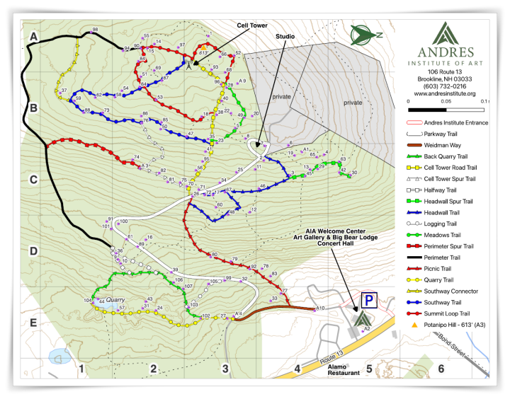
Discovering Art on the Mountain: An In-Depth Guide to the New Andres Institute of Art Trail Map
[Download the Trail Map Now (PDF)]
For decades, the Andres Institute of Art (AIA) in Brookline, New Hampshire, has stood as a remarkable intersection of creative human expression and rugged New England nature. Spanning over 80 acres of forested hillside on Big Bear Mountain, the park serves as a sanctuary for more than 100 monumental sculptures created by artists from all over the globe. Engaging with this vast, open-air gallery, however, has always required a bit of an adventurous spirit. Navigating the winding paths, natural elevation changes, and hidden glades to find a specific work of art could occasionally prove challenging for casual walkers and seasoned hikers alike.
The Andres Institute of Art is thrilled to officially announce the launch of our completely redesigned trail map. Engineered from the ground up to improve accessibility, safety, and engagement, this brand-new navigation tool transforms how visitors interact with the mountain and Sculptures. The updated map is fully optimized for modern hikers and art lovers, and it is available right now for digital download. Visitors can easily grab a copy by visiting the official AIA home page or by navigating directly to the dedicated hiking page before heading out to the trails.
A Collaborative Volunteer Effort
The creation of this new map is a testament to the power of the dedicated volunteer community that keeps the Andres Institute of Art thriving. A project of this magnitude requires an intimate, boots-on-the-ground knowledge of the mountain’s complex terrain, as well as a deep understanding of graphic design and user experience. The primary architect behind this massive undertaking was core volunteer Will Walker. Investing countless hours of meticulous field research and design drafting, Will spearheaded the effort to reimagine the trail layout from a fresh perspective. He worked closely with a passionate internal team (Kristi, Eric M & Dave P) to ensure that every bend in the trail, every major landmark, and every hidden clearing was accurately represented.
A critical phase of the redesign involved establishing a completely new visual language for the park’s trail systems. To achieve this, Will collaborated intensely with team members Kristi and Eric M. Together, this trio developed a unified, intuitive color-coded and shape-based icon system designed to instantly communicate trail difficulty and routing. Furthermore, Will—affectionately known across the hill as Willie—went a step further by conceptualizing and integrating a comprehensive coordinate grid system. This technical addition solves a long-standing puzzle for visitors: how to reliably identify and locate specific sculptures hidden across the expansive hillside. Thanks to the tireless efforts of Will, Kristi, Eric, and the rest of the volunteer team, the mountain has never been more welcoming.
Key Features of the Redesigned Map
The new map moves away from stylized, abstract layouts of the past, replacing them with a highly accurate, functional cartographic design. By blending modern trail navigation standards with specialized art-tracking features, the map addresses the unique needs of a sculpture park guest. Here is a detailed look at the core upgrades visitors will find:
1. The Unified Color-Coded & Shape System
To ensure that every hiker can choose a path that perfectly matches their physical comfort level and time constraints, the new map introduces a dual-classification system using both colors and geometric shapes. This approach aligns with international trail standards, ensuring instant familiarity for experienced hikers while remaining completely intuitive for newcomers.
-
Circle (Easier Trails): These routes are best for visitors looking for the easiest stroll through the woods. They feature wider paths, fewer inclines, and although they aren’t “easy”, they are the easiest paths we have on the mountain. They are better suited for families, casual walkers, first time visitors and anyone wanting to experience the art without signing up for a strenuous workout.
-
Square (Intermediate Trails): These paths offer a moderate challenge, introducing hikers to steeper terrain, narrower woodwalks, and uneven surfaces like exposed roots or rocks. They require a steady foot but reward the hiker with deeper access into the quiet, mid-mountain areas where many incredible sculptures reside.
-
Triangle (More Difficult Trails): Intended for seasoned hikers seeking a true physical workout, these trails feature steep vertical climbs and more rugged terrain. Choosing a triangle path means taking the direct, athletic route up the mountain, offering an exhilarating trek through the beautiful, unblemished landscape.
2. Precision Sculpting Locations via the Coordinate Grid
The crown jewel of the new map is the integration of a precise alphanumeric coordinate system. With well over 100 sculptures scattered across the mountain, trying to find a specific piece—such as an elusive stone carving or a towering steel structure—used to rely heavily on word-of-mouth or pure luck. Willie’s new grid overlay changes the game. Each sculpture is now cataloged with a specific grid location (such as B4 or E2) that corresponds directly to an indexed master list of titles and artists. Whether you are climbing the hill with the explicit goal of finding a newly installed masterpiece from the annual International Sculpture Symposium, or trying to relocate a favorite piece from a past visit, the coordinate system allows you to pinpoint its exact location in seconds.
3. Clearer Landmarks and Navigational Anchors
When hiking on a forested hill, maintaining a strong sense of spatial awareness is crucial. The new map vastly improves the visibility of our primary orientation hubs, making them stand out clearly as anchor points for your journey.
-
The Welcome Center: Clearly marked at the base of the mountain, this acts as your starting and ending orientation point, ensuring you always know how to find your way back to the main parking area and facilities.
-
The Studio: Situated as a key mid-mountain cultural hub, the studio area is now distinctly outlined so visitors can easily use it as a rest stop or meeting point.
-
The Summit: The peak of the mountain is beautifully defined, allowing hikers to easily plot their ascent to the top to enjoy the stunning, panoramic vistas of the surrounding New Hampshire countryside.
-
The Cell Tower: Serving as a prominent physical landmark that can be seen through the trees from various vantage points, the tower is precisely placed on the map to act as a reliable visual compass while you are on the move.
4. Advanced Topographic Contour Lines
For those who want to truly understand the layout of the land before taking their first step, the map now includes detailed topographic (topo) lines. These lines represent changes in elevation across the mountain.When topo lines are spaced far apart, the terrain is relatively flat; when they are tightly bunched together, it indicates a steep slope or drop-off. By studying these contours, hikers can visualize the true steepness of a path ahead of time. This feature is invaluable for individuals managing joint pain, parents pushing rugged all-terrain strollers, or hikers simply wanting to gauge how much effort a particular route will take. It empowers you to pick the best route for your specific physical abilities, making your day on the mountain entirely stress-free.
Plan Your Next Adventure Today
The Andres Institute of Art invites you to experience the mountain in a whole new light. Whether you are a local resident who hikes the trails weekly or a traveling art enthusiast visiting for the very first time, this new map is guaranteed to enrich your journey. It honors the wilderness of Big Bear Mountain while providing the structure needed to fully appreciate the world-class art gallery curated within it. Don’t wait until you arrive at the trailhead to look it over. Head to our home page or visit our dedicated hiking page right now to download the high-resolution map to your smartphone, or print out a copy to bring along with you. Come explore the intersections of creativity, community, and conservation with the ultimate mountain guide in the palm of your hand!